
Some years ago — never mind how long precisely — oh all right, it was January 15, 2003 — I was walking down the street in Oslo. In fact, this street:

I was keeping my head down because, as you can see in the picture, the streets in Oslo can be icy. I had lived in a cold place before — Boulder, Colorado, — but in Boulder, after any snowfall everyone rushes outside and sweeps their sidewalk. It made for quite a festive air. But in Oslo, I never saw any sweeping of sidewalks, and the snow turned to ice. It was a bit before 9am and the sun was not yet up. Oslo lies at 60º north, and 15 January only provides 6 hours 45 minutes of day. However, the sky was clear and it looked liked it was going to be a fine day.
Fortunately, however, I did at some point look up, and what I saw made me stop in my tracks. It was something enormous, spectacular, brilliant, and other-worldly. It was this:
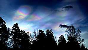
This photo comes from that same day’s paper, which identified the phenomenon as mother-of-pearl clouds. Today, these are a bit better known, but at that point I knew for certain that I had no idea what I was seeing. But I knew it was something remarkable.
Les Cowley at “Atmospheric Optics” writes
Nacreous clouds, sometimes called mother-of-pearl clouds, are rare but once seen are never forgotten. They are mostly visible within two hours after sunset or before dawn when they blaze unbelievably bright with vivid and slowly shifting iridescent colours. They are filmy sheets slowly curling and uncurling, stretching and contracting in the semi-dark sky. Compared with dark scudding low altitude clouds that might be present, nacreous clouds stand majestically in almost the same place – an indicator of their great height.
Now, not only are mother-of-pearl clouds a stunning phenomenon, that indeed I have seen only once but have never forgotten, they are a highly visible sign of climate change. The first known sightings were in Sweden in 1870. Sightings spread to Norway – where they may have inspired The Scream –, and then to Britain in 1884. No more were seen anywhere in the world until 1923. In 1971 they were so unknown in Britain that a scientific article was written about the appearance of a single cloud. There were widespread sightings in Britain in 1999, 2000, 2012, 2016, and 2017; stunning pictures of these clouds are easily found.
Mother-of-pearl clouds form high up, in the stratosphere, from 15-25km in height. They require extremely cold temperatures to form, below the freezing point of water, which at that height is around –85ºC. The greenhouse effect, which traps infrared radiation in the lower atmosphere and heats it, also leads to cooling of the stratosphere. It’s cooled by about 2 degrees since 1958, periodically interrupted by volcanoes whose high-altitude dust particles absorb heat:
It would make a nice story if I could say that was a road-to-Damascus moment for me, a moment that switched me from knowing about climate change, to caring. Alas, that didn’t happen. Looking back, the change was a surprisingly lengthy process. What did the trick in the end was a whole cascade of large-scale changes happening all over the place: the disastrous collapse of the north pole sea ice in 2007; the slowing of the Gulf Stream reported in 2015 causing high-tide flooding; the successive collapses of ice sheets in the Antarctic peninsula, which started in the 1990s but seemed to form a clear pattern by 2010; and the change in the behaviour of the northern jet stream, leading to the now well-known “Omega block” linked to extreme weather of all sorts in the United States.
But perhaps it started with the clouds.
Robert McLachlan
References
1. Stanford, John L., and John S. Davis. “A century of stratospheric cloud reports: 1870–1972.” Bulletin of the American Meteorological Society 55.3 (1974): 213-219. Backhouse, T.W., 1885. Iridescent clouds. Nature, 31(792), p.192.; Piazzi-Smyth, C., 1884. Indescent Clouds. Nature, 31(790), p.148.
2. McIntosh, D. H. “Mother-of-pearl cloud over Scotland” Weather 27.1 (1972): 14-26.
3. Les Cowley, Atmospheric Optics, https://www.atoptics.co.uk/highsky/nacr1.htm
4. The discovery of the ozone hole in 1985 led to a renewed interest in these clouds. In 1988 a distinction was drawn between two types. Type I contain water, nitric and/or sulphuric acid and are a source of ozone depletion, and form at temperatures below –78ºC. Type II, shown above, contain water only and form at temperatures below –85ºC. See Hamill, Patrick, R. P. Turco, and O. B. Toon. “On the growth of nitric and sulfuric acid aerosol particles under stratospheric conditions.” Journal of atmospheric chemistry 7.3 (1988): 287-315.
6. Paul Vitello, “Joseph Farman, 82, Is Dead; Discovered Ozone Hole”, New York Times, May 18, 2013.
7. A related type of high-altitude cloud – also first observed in the late 19th century – is the noctilucent, or night-shining, cloud. These are even higher, at 80km, and may also be linked to climate change, as higher methane levels break down to water vapour. Every record of what we’ve seen in the sky has been the same. As far back in human existence as we know, among the Egyptians, the Native Americans and the Chinese, there is no record that clouds glow in the dark. – Scott Bailey, University of Alaska. Their initial observation in 1885 (from several sites in Europe including the UK, just a few months after the first appearance there of mother-of-pearl clouds) may have been related to the eruption of Krakatoa in 1883, which pumped large amounts of water into the upper atmosphere. See Thomas, Gary E., et al. “Relation between increasing methane and the presence of ice clouds at the mesopause.” Nature 338.6215 (1989): 490.
8. For the changes in the northern jet stream, see Francis, J. and Skific, N., 2015. Evidence linking rapid Arctic warming to mid-latitude weather patterns. Philosophical Transactions of the Royal Society A: Mathematical, Physical and Engineering Sciences, 373(2045), p.20140170.
